***Select the question to view the answer***
General
What’s the zoning of my property?
View the Zoning Map.
Alternately, you can use CityMap, an interactive mapping tool, to find out the zoning designation, future land use designation, and other property information for parcels in Yakima. CityMap allows you to search by parcel number, site address, property owner last name, or organization name.
Can my property be rezoned?
Zoning Districts. A “zoning district” means a portion of the Yakima urban growth area within which certain uses of land and structures are permitted and certain other uses of land and structures are prohibited, certain yards and other open spaces are required and specific lot areas are established, all as set forth and specified in Yakima Municipal Code Title 15. The district intent statements for each zoning district can be found in YMC 15.03.020.
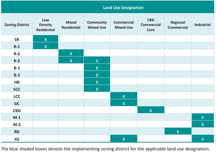
The table of permitted land uses in relation to zoning districts is found in YMC 15.04.030 Table 4-1.
Rezone Request. From time to time, a change in circumstance or condition may warrant a change in the zoning map. An amendment to the zoning map may be initiated by the City of Yakima Planning Commission or the property owner of the subject property. The proposed change must be consistent with the goals, policies, and intent of the Yakima Urban Area Comprehensive Plan.
A property owner may request a rezone by completing the Rezone application and paying the associated application fee. Please note that SEPA Environmental Review (included in the Rezone application packet) is also required and has a separate application fee.
Spot Zoning. Illegal “spot zoning” is arbitrary and unreasonable zoning action by which a smaller area is singled out of a larger area or district and specially zoned for a use classification totally different from and inconsistent with the classification of the surrounding land, not in accordance with a comprehensive plan.
The rezone request will be evaluated to see if it would create a spot zone or a similar change that may create instability with the surrounding neighborhood, which is not consistent with the goals, policies, and intent of the Comprehensive Plan.
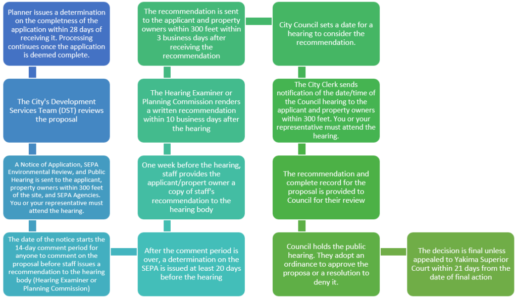
Future Land Use Designation. Just as each property has a zoning designation, each property has an assigned Future Land Use (FLU) designation. The FLU map visualizes the intended uses of areas within the city and urban growth area. If you are seeking to rezone your property but the desired zoning designation is not an implementing zone of the property’s FLU designation, you will have to go through the Comprehensive Plan Amendment (CPA) application.
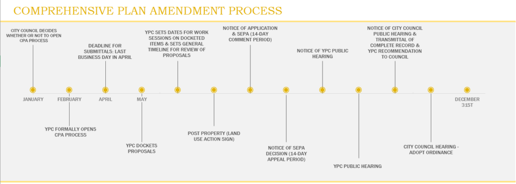
The CPA application packet contains forms for the CPA, Rezone, and SEPA; all 3 have a separate application fee that must be paid. The application process for CPAs is only opened once a year – see timeline below.
What uses are allowed on my property?
Permitted Uses. The chart indicating zones where uses are allowed and the type of review required can be found at YMC 15.04.030. Information on determining the zoning of your property can be found here. If your proposed use is not allowed in the zoning district that the subject property is in, you may speak to a planner regarding the possibility of rezoning the property.
Development Standards. Requirements for setbacks, landscaping, lot coverage, parking, and signs all need to be taken into consideration when developing a property. Such standards can be found in YMC Ch. 15.05 through YMC Ch. 15.08. These requirements may potentially be adjusted under the provisions of YMC Ch. 15.10. Special Development Standards. Some land uses have additional requirements that can be found in YMC Ch. 15.09.
Other Applications that May Accompany the Underlying Land Use Application.
SEPA – Some uses and activities require SEPA environmental review. Uses/activities that exceed the flexible thresholds in YMC Ch. 6.88.070 are required to undergo SEPA review.
Traffic Concurrency Review – A Transportation Concurrency Review application is also required if the proposed use generates more than 10 p.m. peak hour trips.
Critical Areas Review – a Critical Areas Review may also be required. Flood hazard areas, fish and wildlife habitat conservation areas, wetlands, geologically hazardous areas, and areas with a critical recharging effect on aquifers used for potable water constitute the city of Yakima’s critical areas.
Shoreline Development Permit, Conditional Use, or Variance Application – Development within the shorelines may require a shorelines permit. Shorelines are all of the water areas of the state, including reservoirs, and their associated shorelands, together with the lands underlying them; except (i) shorelines of statewide significance; (ii) shorelines on segments of streams upstream of a point where the mean annual flow is twenty cubic feet per second or less and the wetlands associated with such upstream segments; and (iii) shorelines on lakes less than twenty acres in size and wetlands associated with such small lakes. A Shorelines Exemption permit may be applied for if it falls under the exempt developments set forth in WAC 173-27-040 and RCW 90.58.030(3)(e), 90.58.140(9), 90.58.147, 90.58.355, and 90.58.515. These are not required to obtain a shoreline substantial development permit but must otherwise comply with applicable provisions of the Act and the local Shoreline Master Program YMC Title 17.
*Note: this is not intended to be an exhaustive list; please speak to a planner about what applications may be required.
Pre-Application Meeting. The City offers a one-time free pre-application meeting with city’s Development Services Team (DST) in order to understand the development processes and requirements that may be imposed on your proposal. This process is ideal for proposals to develop a vacant lot, redevelop a lot, or subdivide a property. View information about pre-application meetings here.
Links: Application Forms & Fees
What’s the Zoning of My Property?
Pre-Application DST Meeting
Modifications to Existing Uses/Developments
What are the building setbacks for my property?
Purpose. In the residential districts, structure setbacks are intended to provide privacy, light, air and emergency access. Setbacks along easements and rights-of-way are intended to minimize the impacts from traffic on adjoining property owners. In the commercial districts, building setbacks provide visual clearance along streets and areas for sitescreening and landscaping. Structure setbacks are required in the industrial districts to provide fire protection, emergency access, and to reduce impacts on adjacent districts of lower intensity. No structure shall be built or located on or in an easement. The use of an access easement by a structure shall only be allowed upon vacation/alteration of the easement in accordance with provisions established in the city subdivision ordinance.
Setback Standards. In order to determine the setback requirements, you must know what zoning district your property is in and the functional classification of the road that the setback is being determined from (arterial, collector arterial, local access, private road, or private access easement). Instructions for determining the zoning of your property can be found here. Functional classification of roads in the city can be found on CityMap – open the Layers List by clicking on the first icon that appears in the bar at the top of the page. Make sure the box next to “Other Layers” is selected. Then, from that list, turn on “Functional Classification”. Click on the arrow next to Functional Classification to see the color-coded key. Roads that do not fall under any of the categories listed in the key are a local access road, private road, or a private access easement. If you need help determining the zoning of the property or functional classification of a road, please contact us for assistance.
The standard structure setback in each zoning district is shown in YMC 15.05.030 Table 5-1. Setback requirements specific to residential accessory structures and swimming pools are described below.
Setbacks for Residential Accessory Structures. Accessory structures for residential properties, such as detached garages, carports, sheds, pergolas, gazebos, playhouses, etc. need to follow the setback requirements found in YMC 15.05.020(E):
- Residential Accessory Structures Requiring a Building Permit (anything over 200 sq ft):
The minimum setback for residential accessory structures in the residential districts shall be at least five feet from the side property line, five feet from the rear property line, and up to, but not within, the required front yard setback; provided, that the accessory structure(s) shall not encroach on a public easement and applicable street setbacks are observed. - Residential Accessory Structures Not Requiring a Building Permit (anything under 200 sq ft):
The minimum setback for a residential accessory structure in a residential district shall be at least five feet from any existing structures and can be up to zero feet from the side and rear property lines, and up to, but not within, the required front yard setback; provided, that the accessory structure shall not encroach on an easement.
Setbacks for Swimming Pools.
- Front yard: The swimming pool, apron, and pump house meet the required front yard setback in YMC 15.05.030 Table 5-1.
- Side and rear yard: The swimming pool and pump house are set back at least three feet from the property line. The swimming pool apron may extend up to the property line.
- From an easement: The swimming pool, apron, and pump house may extend up to, but shall not encroach upon, an easement.
Please note that the area around the pool must be enclosed by a protective fence not less than four feet in height OR by another prescriptive measure as permitted by the Washington State Residential Code.
Administrative Adjustment of Standards. In some circumstances, it may be permissible to place a structure closer to a property line or structure than what is allowed by the code. This may be achieved through an Administrative Adjustment application process in which the applicant must provide answers to the narrative questions in the application packet demonstrating the need and compatibility for such adjustment (download application here).
Building Permits. For residential projects falling under the scope of the Washington State Residential Code, the city’s Code Administration does not require a building permit when constructing a one-story detached accessory structure with a floor area of 200 sq ft or less. Swings and other playground equipment accessory to detached one- and two-family dwellings are also exempt from the building permit process. See a full list of exemptions here. The building permit application can be downloaded here: https://www.yakimawa.gov/services/codes/permits/
Can I subdivide my property?
Lot Size and Width Requirements. The first factor in determining if property can be subdivided is to clarify the minimum lot size required. See the chart in YMC 15.05.030(C)(1) and in YMC Ch. 15.05.030 Table 5-2. Minimum lot width is also included in Table 5-2.
Other considerations in determining the feasibility subdividing may include lot coverage and setbacks standards. These can be found in YMC Ch. 15.05.030 Table 5-1.
Utilities. Sewer availability can be confirmed by the city’s Wastewater Division which can be reached at (509) 575-6077. To confirm water/irrigation availability, please check with the appropriate water service provider based on your location. Not sure who the provider is for the area? Call the Water/Irrigation Division at (509) 575-6154 or use CityMap by zooming into the area of interest, clicking the “layer list” icon in the top right, selecting the box next to Water Department, and selecting the box next to service areas in the list that populates below.
DST Pre-Application Meeting. If you’re interested in meeting with city staff and other relevant parties (our “Development Services Team” (DST)) to discuss the potential of subdividing a property prior to submitting a formal application and application fee, you can submit a pre-application meeting request on our online permit center – instructions listed here. The first pre-application meeting is free. A preliminary site plan will be required showing the proposed layout of the lots and streets, the names of existing abutting streets, any existing structures on site, etc. Generally, the more info you provide, the more detailed comments our DST members can relay to you.
Application Process. Our subdivision applications can be downloaded from our application forms and fees page and filled out on your computer. If you are subdividing property into 9 lots or fewer, fill out the preliminary short plat application form; for 10 or more lots, fill out the preliminary long plat application. It is highly recommended that you hire a state licensed land surveyor or engineer to prepare the preliminary plat due to the level of detail required for review. See the application packet for more information on the review process.
If your preliminary plat is approved, a final plat application will need to be submitted subsequent to meeting all conditions of approval imposed on the preliminary plat. A final plat must be prepared by a licensed surveyor.
Where are my property lines?
Land Survey. Property owners may hire a land surveyor to mark their property lines for them, as surveyors have the knowledge and resources to accurately depict these points (note: city staff does not provide this service; a private land surveying company must be hired).
Estimated Property Line Locations and Lot Dimensions. CityMap is an interactive mapping tool that anyone can access. You can find it online here: https://gis.yakimawa.gov/citymap/
Disclaimer: the City of Yakima assumes no liability for any errors, omissions, or inaccuracies in the information provided or for any action taken, or action not taken by the user in reliance upon any maps or information provided therein.
Lot Line Adjustments. Property owners can request to change the location of their property lines through the Short Plat Exemption application process, or merge multiple parcels together. The application form can be downloaded online: https://www.yakimawa.gov/services/planning/land-use-application-forms/
Where can I put my fence on my property and how tall can it be?
The first step in determining where you can put your fence is to know the exact location of your property lines. Property owners may hire a land surveyor to mark their property lines for them, as surveyors have the knowledge and resources to accurately depict these points (note: city staff does not provide this service; a private land surveying company must be hired).
The next step is to review the regulations in Yakima Municipal Code (YMC) § 15.05.020 (G) for fence height and location. Generally, fence height limitations are dependent upon:
a) The zoning of your property;
b) Which yard the fence is in; and
c) Whether the fence is within the required setback area or behind it (see setback requirements in YMC § 15.05.030 Table 5-1)
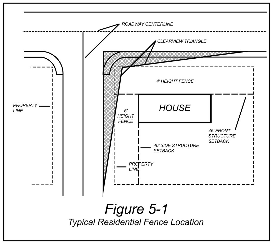
Please note that your fence must be on or behind your property line. If you have a corner lot, any fencing within the clearview triangle cannot be taller than 2 and ½ feet for safety vision purposes (see additional information on the clearview triangle in YMC § 15.05.040 and images below). Fences in the right-of-way may be allowed by obtaining a right-of-way use license, which requires annual fees and a certificate of insurance to be filed with City Codes each year.
In some circumstances, it may be permissible to construct a fence that is taller than what the code allows. This may be allowed through an Administrative Adjustment application process in which the applicant must provide answers to the narrative questions in the application packet demonstrating the need and compatibility for such adjustment (download application here). A building permit is also required for the fence if it is over 7 feet in height.
How do I find information about easements on my property?
Easement Purposes. Easements can be established on properties in order to grant access for individuals who are not owners of the property to pass through (e.g. if a property is landlocked so the only way to access their property would be to go through a neighboring parcel). Another purpose of an easement would be for utilities in order to allow the city, utility company, etc. to access that portion of your property to access the utilities. It’s important to note that nothing can be permanently built within an easement.
Documentation. The first place to look for indications of easements is in your title report for your property. Another resource is the record of survey, which may be requested from Yakima County through a public records request.
Establish or Vacate. For questions pertaining to establishing or vacating an easement, please contact us at (509) 575-6183 or ask.planning@yakimawa.gov to speak with a planner.
Can a house or other residential structure be located anywhere other than a residential zone?
You may have noticed that some houses in the city of Yakima have been established in a commercial or industrial zoning district rather than residential. The Yakima Municipal Code (YMC) dictates that construction of new housing may be allowed in certain commercial and industrial zoning districts through the appropriate land use review. The chart indicating zones where types of residential uses are allowed and the level of land use review required can be found in YMC 15.04.030.
Nonconforming uses. The municipal code defines “nonconforming use” as follows: “Nonconforming use’ means a use of land or structure lawfully established and maintained, but which does not conform to this title for the district where it is located.”
The YMC provides for the continuation of nonconforming uses (see YMC 15.19.050). As such, if a single-family home or other housing type was constructed in a zoning district where it is now no longer permitted under the current code, the house may continue to be used and if destroyed can be rebuilt as it was prior to the damage if a building permit application for reconstruction/replacement is made within 18 months of such damage. No land use review will be required. Transfer of ownership will also not affect the continuance of the nonconforming use (YMC 15.19.110).
See also: Illegal uses, structures and lots not permitted (YMC 15.19.020)
Establishment [of legal nonconformity] (YMC 15.19.030)
Development on existing lots of record (YMC 15.19.040)
Continuation of nonconforming uses (YMC 15.19.050)
Nonconforming Structure (YMC 15.19.060)
Change from a nonconforming use to a Class 1, 2, or 3 use (YMC 15.19.070)
Change from a nonconforming use to another nonconforming use—Expansion of a
nonconforming use or structure (YMC 15.19.080)
Modifications of an approved site plan for a nonconforming use or structure (YMC
15.19.090)
Discontinuance of a nonconforming use or structure (YMC 15.19.100)
Sale of a nonconforming use or structure (YMC 15.19.110)
Critical area nonconforming uses and facilities (YMC 15.19.120)
How does the City of Yakima regulate cannabis uses?
Regulations for cannabis retail, processing, production, and research are outlined in the Special Development Standards chapter of the Yakima Municipal Code (YMC 15.09). View more information here.
What signage regulations do I need to follow?
Sign Standards. YMC Chapter 15.08 contains the regulations for signs based on sign type and the zoning district in which it is proposed to be located. The regulations in this chapter are intended to promote traffic safety, recognize free speech rights by regulating signs in a content-neutral manner, allow the free flow of traffic, and protect pedestrians and motorists from injury and property damage caused by, or attributable to, cluttered, distracting and/or illegible signs.
YMC 15.08.060 contains three tables (Table 8-1, 8-2, and 8-3) that dictate the allowed type, number, height, maximum area, and setbacks for signs. Please see YMC 15.08.020 for a list of definitions that will also help you in determining the signage requirements.
Changes or Replacement of an Existing Sign. Changes to the face or copy of a sign does not require review by the Planning Division. However, if the size, height, or location of the sign is changing, please contact us so we may determine the necessary requirements.
Prohibited Signs. The following signs are prohibited:
- Signs on any vehicle or trailer parked on public or private property and visible from a public right-of-way for the purpose of circumventing the provisions of this chapter. This provision shall not prohibit signs painted on or magnetically attached to any vehicle operating in the normal course of business.
- Signs purporting to be, imitating, or resembling an official traffic sign or signal by its color, design, location or illumination; which could cause confusion with any official sign, or which obstruct the visibility of any traffic/street sign or signal or pedestrian by glare or method of illumination.
- Signs attached to utility, streetlight and traffic-control poles or facilities, signs attached to fences owned by the city, or signs placed on trees.
- Swinging projecting signs.
- Signs in a dilapidated (i.e., having peeling paint, major cracks or holes, and/or loose or dangling materials) or hazardous condition.
- Abandoned signs.
- Signs on doors, windows or fire escapes that restrict free ingress or egress; and
- Any other sign not meeting the provisions of this chapter.
To report a violation of these standards, please file a code complaint.
How do I obtain permission to close a street or sidewalk for an event?
Special Event. A “Special Event” is any fair, show, parade, run/walk, festival, or other publicly attended entertainment or celebration which is to be held in whole or in part upon publicly owned property or public rights-of-way, or if held wholly upon private property, will nevertheless affect or impact the ordinary and normal use by the general public of public property or public rights-of-way within the vicinity of such event.
Any person or entity who conducts, promotes, or manages a special event or parade shall first obtain a special event permit from the Planning Division pursuant to the procedures found in YMC 9.70. The special event application form can be found on our application forms and fees page, along with the special event guidelines packet which contains important details about the application process and requirements.
Block Party. In order to close the street that you live on for the purpose of hosting an event for you and your neighbors, a block party permit would be required instead. This is a streamlined permitting process. This application form can also be found on our application forms and fees page. Please note that if your block party is part of National Night Out, then you are exempt from the permitting process but must notify the Yakima Police Department of the planned street closure.
Can I put a cargo/storage container on my property?
Cargo containers can be placed on properties in residential zones for a maximum of two consecutive weeks at a time.
Cargo and/or semi-truck trailers are allowed as an accessory use to a permitted business in the B-1, B-2, SCC, LCC, AS, GC, RD, M-1 and M-2 zoning district. Accessory cargo containers and/or semi-truck trailers shall be processed under the provisions of YMC Ch. 15.17, Modifications to existing or approved uses or development, subject to the following conditions:
a. All refrigerated cargo containers and/or semi-truck trailers that are not located within a designated loading dock or loading bay shall be located no less than fifty feet from any existing residential zoning district.
b. Placement of cargo containers and/or semi-truck trailers shall not adversely affect maximum lot coverage, landscaping requirements, or required on-site parking spaces.
How can I report a zoning code violation?
Contact Code Compliance at (509) 576-6657, stop by the Codes/Permitting counter during business hours to make a complaint in person, or submit a Yak Back request. See the Code Compliance webpage for more info.
Regarding Your Residence
Can I operate a business out of my home?
Allowed Uses. Certain types of home occupations are permissible depending on the zoning district your property is in. The chart indicating zones where uses are allowed and the type of review required can be found in YMC 15.04.120. Uses in the chart that are identified as Class 1 Uses do not require land use review, you may apply directly for your business license. Uses identified as Class 2 or 3 uses must go through a one-time land use review process (see the Home Occupation Application on our applications page).
ALL home occupations are required to obtain a City of Yakima Business License which must be renewed annually. Your State and City business licenses must be applied for and obtained through the Washington State Department of Revenue: https://dor.wa.gov/open-business
If your home occupation land use review application is approved, we will release your city business license to the State, and they will send your license to you.
Home Occupations in Commercial or Industrial Zones. Proposed Home Occupations in existing dwellings in the commercial and industrial zoning districts shall follow the land use requirements of the R-3 zoning district in Table 4-2.
Prohibited Home Occupations. The following uses are not permitted as home occupations: auto repair; antique shop or gift shop; kennel; veterinary clinic or hospital; painting of vehicles, trailers or boats; large appliance repair including stoves, refrigerators, washers and dryers; upholstering; machine and sheet metal shops; martial arts school; taxidermist; two-way radio and mobile telephone system sales and service; and vehicle sign painting (except for the application of decals).
Unclassified Uses. Home occupations not listed in Table 4-2 shall be reviewed by the hearing examiner in accordance with the provisions of YMC Chapter 15.22; provided, any unclassified home occupation permitted after review and decision by the hearing examiner in a particular district shall be allowed only as a Class (2) or (3) use.
Necessary Conditions. All home occupations must abide by the 13 conditions listed in YMC Ch. 15.04.120 (C).
See YMC Ch. 15.04.120 for additional details, including regulations for signage, parking, and storage of equipment, materials, and goods.
Links: Table of Permitted Home Occupations (Table 4-2 in YMC Ch. 15.04)
What’s the Zoning of My Property?
Land Use Applications & Fees
Does the City of Yakima allow people to rent their homes or a room in their homes for tourists?
Short-term stays such as those offered through online rental facilitators like Airbnb and VRBO which provide tourists and others with short-term transient lodging options may be permitted when the property owner goes through the appropriate land use review. Bed and Breakfasts also fall under the category of “short-term rental.”
Operating a Short-Term Rental in the City of Yakima. As governed by Yakima Municipal Code (YMC) Ch. 15.04, short-term rentals can be located in the CBD zoning district through a Type 1 land use review, and may be permitted in the SR, R-1, R-2, R-3, B-1, SCC, LCC, and GC zoning districts through a Type 3 Review. This is a one-time land use review process that’s required before you can receive your business license.
Alternately, if the owner resides in the house in which they wish to rent out a portion of on a short-term basis, and the house is in a residential zone, this is an outright permitted use not requiring land use review. In this situation, owners are limited to having not more than five lodging units or guest rooms and must follow the other special regulations listed in YMC 15.09.080, as well as the general home occupation stipulations found in YMC 15.04.120.
License Required. Please note that all owners of rental properties, whether intended for short-term stays OR on a more permanent basis, are required to obtain a City of Yakima Business License which must be renewed annually.
Links: Licenses Page
Land Use Application & Fees Page
What’s the Zoning of My Property?
What animals am I allowed to keep on my property?
The Yakima Municipal Code provides regulations for keeping animals on property within the city of Yakima; this includes pets, animal husbandry, kennels, and pet daycares/training facilities:
Pets
Pets are domesticated animals kept for pleasure or as a hobby rather than utility, including, but not limited to:
- Fish; birds; dogs (limited to 3); cats (limited to 5); hen chickens (limited to 4), no roosters allowed; and rabbits (limited to 4).
Key Points & Regulations:
- The other provisions of the YMC for animals shall be followed.
- Their presence must not create undue noise or odors
- Animals shall be properly fed, watered and kept in a humane manner
- Any chicken coops, chicken tractors, or rabbit hutches shall be set back 10 or more feet from any residence or property line, and 5 feet from other structures including decks
- Hen houses, coops, hutches, and chicken tractors shall be restricted to the backyard area
- For chickens and rabbits, adequate fencing shall be installed to contain the animals within the backyard.
Animal Husbandry
“Animal husbandry” means the raising of domesticated farm animals when, in the case of dairy cows, beef cattle, horses, ponies, mules, llamas, goats and sheep, their primary source of food, other than during the winter months, is from grazing in the pasture where they are kept.
Key Points & Regulations:
- Minimum lot size: one-half acre.
- A decision with conditions of approval or a decision of denial may be issued if the operations would create nose, odors, attract insects or rodents, or would otherwise be incompatible with the surrounding residential uses or intent of the zoning district.
- No portion of any structure used to house a domesticated farm animal shall be located within 100 feet of any residence other than a dwelling on the same lot.
- No portion of any structure used to house a domestic farm animal shall be located within 10 feet of a residence where the residence and domestic farm animal structure are located upon the same lot/tax parcel.
- The maximum number of animals that may be kept on the site at any time of the year shall be the number of animals that can be sustained by the pasture on which they are kept as their primary source of food, except during the winter months. The burden of proving that the pasture can sustain the number of animals in question shall be on the applicant.
- Fencing adequate to contain the animals shall be provided and maintained.
Animal husbandry is permitted in the SR, M-1, and M-2 zoning districts under a Type 1 Review process, and may be permitted in the R-1 zoning district under a Type 2 Review process.
Kennels
“Kennel” means a building, enclosure or portion of any premises in or at which dogs, cats or other domesticated animals are boarded or kept for hire; or in or at which dogs, cats or other domesticated animals are kept or maintained by any person other than the owner; or in or at which 6 or more cats or four or more dogs over the age of 4 months are kept or maintained. This definition shall include boarding kennels, but not pet shops, animal hospitals or zoos.
Kennels may be permitted in the SR, M-1, and M-2 zoning districts under a Type 2 Review process.
Day Care/Animal Training
“Pet day care” means a building or structure in which an agency, person or persons regularly provide care for pets, but not including overnight stays. Uses not meeting this definition shall be considered kennels.
Pet day care/animal training uses are permitted in the B-2, SCC, LCC, GC, and RD zoning districts under a Type 1 Review process, and may be permitted in the SR, AS, and M-1 zoning districts under a Type 2 Review.
Links: Table of Permitted Land Uses (Table 4-1 in YMC Ch. 15.04)
What’s the Zoning of My Property?
Land Use Applications & Fees
Code Administration (handles dog licensing)
Yakima Police Department (handles animal-related complaints)
How do I obtain a flood elevation certification for my property?
If you believe a flood elevation certificate has been prepared for your property and you need a copy, please submit a public records request. If there is not one on file and you are in need of one for your property, please contact a licensed land surveyor; the city does not provide this service.
Where can I place a mobile home or manufactured home within the city limits?
Definitions. “Mobile home” means a dwelling on one or more chassis for towing to the point of use which does not meet applicable HUD manufactured housing standards of June 15, 1976. This definition does not include modular homes, manufactured homes, commercial coaches, recreational vehicles or motor homes. “Manufactured home” means a dwelling on one or more chassis for towing to the point of use which bears an insignia issued by a state or federal regulatory agency indicating that the structure complies with all applicable construction standards of the U.S. Department of Housing and Urban Development definition of a manufactured home and was built after June 15, 1976. Manufactured homes are further classified as single-wide or multi-wide (see full definitions in YMC 15.02.020).
Permitted Locations and Siting Requirements. Table 4-3, found in YMC 15.04.160, shows where mobile and manufactured homes can be permanently placed and what level of land use review is required, and describes siting standards for manufactured homes in residential districts outside of a manufactured home park, including requirements for roofing and siding materials, roof slope, and pit set. This code section also explains how existing manufactured homes can be replaced. Mobile/manufactured homes for nonresidential purposes are permitted in all zoning districts and are subject to compliance with other standards of the zoning district (YMC 15.04.170).
Mobile/Manufactured Home Parks. Mobile home parks are allowed in the following zoning districts per YMC 15.04.030 Table-4-1: Suburban Residential (SR), Multi-Family Residential (R-3) and General Commercial (GC) (need to know what the zoning is for a piece of property? Contact us or follow instructions here: https://www.yakimawa.gov/services/planning/zoning-land-use-information/) Standards and criteria for development and expansion of mobile/manufactured home parks can be found in YMC 15.04.150.
Temporary Hardship Units. A mobile/manufactured home may be permitted as a temporary use in all zoning districts if it meets the requirements for a temporary hardship unit listed in YMC 15.04.140.
Can I build, plant, or put a fence on my property within the clear view triangle?
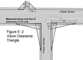
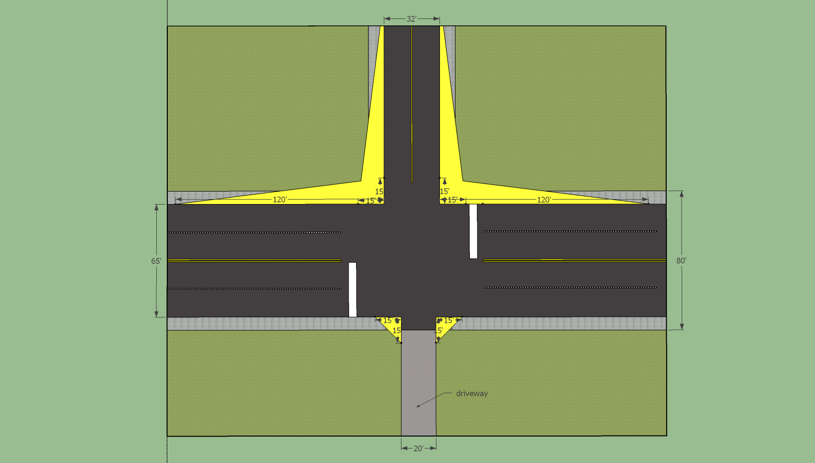
Purpose. The vision clearance triangle, or “clear view triangle,” indicates the areas on a property where there shall not be any obstructions that may block the driver’s view. This applies to corner lots at unsignalized intersections, as well as driveways and alleyways. The Yakima Municipal Code section addressing clearview triangles is YMC 15.05.040.
Obstructions. Items that may obstruct a motorist’s view include any plantings, fences, buildings, or anything that is erected, placed, or allowed to grow within the clear view triangle that is over 2 ½ feet tall.
Clear view triangle measurements. The clear view triangle for corner lots shall measure fifteen feet by one hundred twenty feet along the perpendicular lengths formed by three points including:
1. A point at the intersection of the extended curb lines or pavement edge/travel lanes;
2. A point measured one hundred twenty feet from the first point, forming a line along the adjacent perpendicular street curb line or pavement edge/travel lane; and
3. A point measured fifteen feet from the first point, forming a line.
For driveways and alleyways, the clear view triangle shall measure fifteen feet along the perpendicular street curb lines, pavement edge, or travel lane of the public street and fifteen feet along the driveway or alley. The third side of the triangle shall be a straight line connecting the fifteen-foot sides described above. No sign or associated landscaping shall be placed within this triangle so as to materially impede vision between the heights of two and one-half and ten feet above the centerline grade of the streets.
Are Accessory Dwelling Units (ADUs) permitted in the city of Yakima?
ADUs are one way to supply affordable housing and provide property owners with extra income. They are allowed on lots containing a single-family residence, and may be attached to the primary residence, attached to or above a detached garage, or be its own stand-alone structure. ADUs are allowed on all parcels containing a single-family dwelling without requiring land use review in all zoning districts EXCEPT for the AS, CBD, and M-2 zoning districts; ADUs are not permitted in those three zones. A building permit through the Code Administration must be obtained.
Requirements. ADUs must not exceed 1,000 sq ft in floor area, and must follow other requirements related to setback requirements, aesthetics, and connections to public sewer and water (if available within 200 feet). See YMC 15.09.045 for a complete list of requirements.
Please note that a parcel/lot cannot have more than one single-family residence and one ADU. Also, ADUs are not permitted on parcels containing a duplex or multifamily dwelling, or a commercial or industrial structure/use.
What regulations do I need to follow for putting up an accessory structure at my residence?
Accessory structures for residential properties, such as detached garages, carports, sheds, pergolas, gazebos, playhouses, etc. need to follow the setback requirements found in YMC 15.05.020(E):
Setbacks for Residential Accessory Structures.
- Residential Accessory Structures Requiring a Building Permit (anything over 200 sq ft):
The minimum setback for residential accessory structures in the residential districts shall be at least five feet from the side property line, five feet from the rear property line, and up to, but not within, the required front yard setback; provided, that the accessory structure(s) shall not encroach on a public easement and applicable street setbacks are observed. - Residential Accessory Structures Not Requiring a Building Permit (anything under 200 sq ft):
The minimum setback for a residential accessory structure in a residential district shall be at least five feet from existing structures, up to zero feet from the side and rear property lines, and and up to, but not within, the required front yard setback; provided, that the accessory structure shall not encroach on an easement.
Adjustment of Standards. In some circumstances, it may be permissible to place an accessory structure closer to a property line or structure than what is allowed by the code. This may be achieved through an Administrative Adjustment application process in which the applicant must provide answers to the narrative questions in the application packet demonstrating the need and compatibility for such adjustment (download application here).
Building Permits. The city’s Code Administration does not require a building permit when constructing a one-story detached accessory structure with a floor area of 200 sq ft or less. Swings and other playground equipment accessory to detached one- and two-family dwellings are also exempt from the building permit process. Contact the city’s Code Administration for a full list of exemptions. The building permit application can be downloaded here: https://www.yakimawa.gov/services/codes/permits/
Can I have a well on my property?
Lot Size Requirements. The Yakima Municipal Code imposes lot size requirements that must be met in order to have a well (individual water system). See the table in YMC 15.05.030(C) for these requirements.
Yakima Health District. If your lot does in fact meet the requirements in the table, you will need to contact the Yakima County Health District, who ultimately makes the decision. The Health District may determine that a larger area is necessary for the safe installation of approved water supply.
Yakima County Health District: (509) 575-4040
You may also find the resources on the Yakima County Health District’s website to be helpful in regards to wells: http://www.yakimacounty.us/340/Drinking-Water
Can I have my own septic system on my property?
Lot Size Requirements. The Yakima Municipal Code imposes lot size requirements that must be met in order to have your own septic system. See the table in YMC 15.05.030 for these requirements.
Yakima Health District. If your lot does in fact meet the requirements in the table, you will need to contact the Yakima County Health District, who ultimately makes the decision. The Health District may determine that a larger area is necessary for the safe installation of the sewage system.
Yakima County Health District: (509) 575-4040
You may find the information about septic systems on the Yakima County Health District website to be useful: http://www.yakimacounty.us/335/Septic-Systems
Mapping & Addressing
How do I determine if a property is in the city or county?
Use the Yakima City Limits Lookup Map and search for the property by address or parcel number.
Is my property in the floodplain or in an overlay?
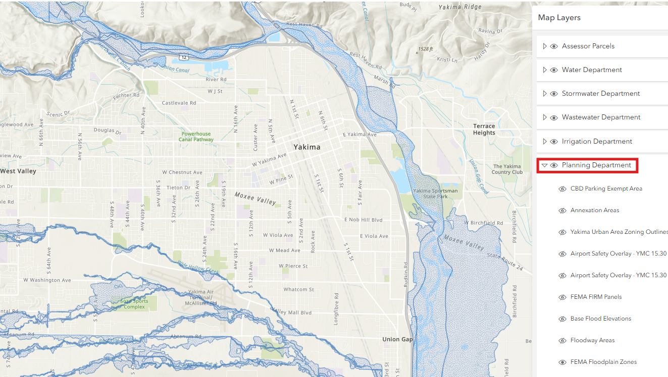
Overlays. The city’s district overlays include the Airport Safety Overlay, Floodplain Overlay, Greenway Overlay, Institutional Overlay, and Master Planned Development Overlay. The purpose of each overlay is described in YMC 15.03.020.
Mapping. Using the city’s interactive mapping tool CityMap, you can enter your address or parcel number in the search bar and turn on the mapping layers for the overlays.
To access the layers, click on the first icon that is in the top bar of the page. Click the arrow next to the Planning Department section to expand the list. Select the eye icon next to the layer you want to have visible/displayed on the map.
Note: there are not layers for the Institutional Overlay or the Planned Development Overlay. If you need to know if a property is in either of these overlays, please contact us.
How can I request to have a physical address assigned to my property or request a change in address?
Some properties, such as those that are undeveloped, may not have a specific physical addressed assigned to them. If you are the owner of such a property that is in the Yakima city limits and need an address to be assigned to it, please contact the city’s Code Administration – (509) 575-6126 or codes@yakimawa.gov.
If you want to a request a change to the physical address of a property, please fill out the City of Yakima Address Change Request Form found on the Permits Page and see the instructions listed thereon for submittal.
How can I request a copy of a Zoning Map or Future Land Use Map?
The city has several maps available on our Geographic Information Systems (GIS) portal, including Zoning and Future Land Use. If you need a physical copy, you may purchase a small or large copy.
- Small map measurements: 24 in. x 36 in.
- Large map measurements: 40 in. x 62 in.
Please refer to the fee schedule on our Application Forms and Fees page. You can place your order by calling us at (509) 575-6183 or emailing to: ask.planning@yakimawa.gov. Once we let you know your order is ready, the fee can be paid and maps can be picked up from the Permits Counter on the 2nd floor of City Hall.
What are the guidelines for mail service for new developments – both residential and commercial?
The United States Postal Service establishes the method of mail service delivery for all new commercial or residential developments. The mode of delivery includes:
- Type of mailbox you will use.
- Location of the mailbox for each delivery address.
Please refer to the USPS National Delivery Planning Standards – A Guide for Builders and Developers and arrange for a local USPS Growth Manager to review your development plans prior to submitting permit applications to the City of Yakima. The Yakima Post Office contact is David James and he can be reached at (509) 225-1362 or by email david.r.james@usps.gov for any questions or concerns.
City Boards & Commissions
What is the role of the Yakima Planning Commission?
Yakima Planning Commission. The Planning Commission is comprised of volunteers appointed by City Council who assist the city by carrying the following responsibilities:
1. Serving as the long-range planning body for the city of Yakima;
2. Monitor the growth and development of the city and continually reevaluate and recommend to the city council revisions to the comprehensive plan and zoning ordinance for the city;
3. Develop and recommend to the city council a subdivision ordinance for the city and revisions thereto;
4. Investigate and make recommendations on other land use matters as may be requested by the city council or on its own initiative;
5. Study and report on all proposed text changes to land use ordinances;
6. Advise the city council on land use matters;
7. Monitor the hearings of the hearing examiner in order to remain informed on development activities, public concerns and the decisions of the hearing examiner;
8. Such other planning functions as authorized or required by law or ordinance or as requested or assigned by the city council.
There is a time for audience participation at each Planning Commission meeting during which time anyone can address the Commission related to any issues relevant to its duties as listed above. More information about the Commission and links to the agenda packets and minutes can be found on this webpage: https://www.yakimawa.gov/services/planning/planning-commission-meetings/ If you would like to be on the email list to receive meeting agendas, please send an email to: ask.planning@yakimawa.gov.
What is the role of the Historic Preservation Commission?
Historic Preservation Commission. The duties of the Historic Preservation Commission are to make determinations concerning the eligibility of historic properties; verify that improvements are consistent with Washington State Advisory Council’s Standards for Rehabilitation and Maintenance; enter into agreements with property owners for the duration of the special valuation period; approve or deny applications for special valuation; and monitor the property for continued compliance with the agreement.
Visit the HPC webpage for more information: https://www.yakimawa.gov/services/historic-preservation-commission/
What is the role of the Yakima Tree Board?
Yakima Tree Board. The Yakima Tree Board was established by the Yakima City Council on December 6, 2016 by Ordinance No. 2016-032. The Tree Board is responsible for studying, investigating, developing, updating, and administering a written plan for the care, preservation, pruning, planting, replanting, removal, or disposition of trees and other plantings in City parks, along City streets, and in other City-owned public areas.
Visit the YTB webpage for more information: https://www.yakimawa.gov/services/planning/yakima-tree-board/
Common Referrals / Phone Numbers:
Note: phone numbers are subject to change. Please perform an online search if the information below is out-of-date.
City of Yakima Code Administration – (509) 575-6126
City of Yakima Engineering Division – (509) 575-6111
City of Yakima Wastewater Division – (509) 575-6077
Yakima County Planning Dept. – (509) 574-2300
Yakima County Assessor’s Office – (509) 574-1100
Yakima County Auditor’s Office – (509) 574-1310
Yakima County Health District – (509) 575-4040